What is Datum
According to Merriam-Webster Datum is defined as “1. Something given or admitted especially as a basis for reasoning or inference 2. something used as a basis for calculating or measuring” [1]Datum | Definition of Datum by Merriam-Webster (merriam-webster.com)
Datum is a relationship between mapping, GPS, and the earth and is very important. Without a common datum, we would not have a starting point.
To start the explanation we need to consider the shape of the earth. The earth is not completely round like a circle, but more of an ellipsoid. Furthermore, if you try to draw a circle around the earth, parts of the earth will fall below or above the circumference of the circle since the surface of the earth is irregular. The irregularities are caused by mountains, valleys, and even the ocean. Sea level is not always constant either, it varies based on tides, barometric pressure as well as storm surges.
Clark Spheroid of 1866 and NAD 1927
Back in 1866 Colonel Alexander Ross Clarke (1828–1914), a British Geodesist who mapped Britain back in 1858 via triangulation, developed the Clarke spheroid of 1866. This spheroid helped geodetics determine the size and shape of the earth and the exact points on its surface, The North American Datum (NAD) of 1927 used a point on the Clarke spheroid of 1866. This point was Meades Ranch in Kansas 39°13’26.686″N latitude by 98°32’30.506″W longitude from the Greenwich prime meridian which was also used. This triangulation station was the starting point in developing the NAD 1927.
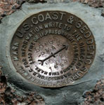 In the late 1800’s surveyors started a monumental project of placing brass or aluminum markers. Each marker was connected using techniques like triangulation. From this network of markers and the result of the calculations, the North American Datum of 1927 (NAD 27) was created. The NAD 27 is the datum used for Topographic mapping in the United States. Later geodesists developed NAD 83 which is a more accurate datum still used today. Between these two datums, they provide the latitude and longitude framework for the whole earth.
NAD27 and NAD83
The difference between the NAD 27 and NAD 83 is that NAD 83 uses data from terrestrial and Doppler satellites. This corrects some distortions from NAD 27. NAD 83 uses about 250,000 markers compared to 26,000 for NAD 27. NAD 83 also uses an Earth-center reference rather than a station on the surface. The error for the center of the earth is about 2 meters.
Once the Global Positioning System (GPS) became part of the mainstream, World Geodetic System (WGS84) became the reference for this system. We now have the ability to pinpoint virtually any point on Earth with great accuracy. WGS84 also has an Earth-center point and is estimated to be within 2 cm of the center of the Earth’s mass[2]1.0 NASA/TP-1998-206861 (SECTION 11)
Because of the differences and inaccuracies when comparing your location from a GPS to a map created with NAD 27 datum, a correction must be made. Most modern GPS has the ability to change its datum reference. On Topographical maps, there is usually a key located at the lower-left corner of the chart. Older maps may use NAD 27. Newer maps will have either been updated to NAD 83 or have a correction from NAD 27 to NAD 83. For instance, the map key may tell the difference between the two datums. It will state that all locations have moved 60 meters east and 6 meters north, for example. If your map is using NAD 27 configure your GPS to use the same. If you are using a NAD 83 chart then have your GPS use either NAD 83 or WGS84.
For more information on GPS click on it. Click here for information on using a compass and map.