Before you hit the trail
It is always a good idea to check the forecast before you hit the trail. The National Weather Service is an excellent resource. Mtntrekker Weather Forecasts is also a good place to start.
On the trail
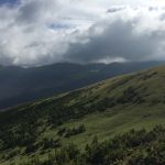
Once you are on the trail, clouds are a tool that can be used to forecast changes in the weather. The cloud type and the direction of their movement are your first clue of potential weather changes. Reading clouds can warn you of weather changes for tomorrow or of storms that are imminent.
Identifying Clouds
The first step in identifying clouds is to understand their naming. Clouds are named for their altitude where they are and for their shape.
Group |
Height |
Types |
| High Clouds or Cirrus | Above 16,000 feet | Cirrus Cirrostratus Cirrocumulus |
| Mid Altitude Clouds or Alto | 6,500 feet to 23,000 feet | Altostratus Altocumulus |
| Low Clouds or Stratus | Up to 6,500 feet | Stratus Stratocumulus Nimbostratus |
| Clouds with vertical development | Cumulus Cumulonimbus |
Cloud Characteristics
 |
Cumulus: “heap, or accumulation” Cumulus clouds are at low altitudes whereas Altocumulus as pictured is at mid-altitudes. |
 |
Stratus: “continuous horizontal sheets” |
 |
Nimbus: “rain clouds” Combined with stratus and cumulus forming nimbostratus or cumulonimbus meaning rain clouds and Thunderstorms. |
What are the clouds trying to say?
Cirrus or Cirro can be used with cumulus Which makes cirrocumulus that looks like high fluffy clouds. Cirrocumulus clouds can indicate fair weather in winter. Cirro is also a prefix to stratus to form cirrostratus which is the name for the high, flat, or layered cloud. which may indicate the approach of a warm front.
Alto can also be used with cumulus and stratus to name mid-level clouds: altocumulus and altostratus.
Nimbus or Nimbo is the suffix or prefix used with cumulus or stratus to name the cloud type that is producing precipitation. These clouds could be either cumulonimbus which would be a fluffy, vertically-rising rain cloud like a thunderstorm, or nimbostratus which would be a sheet-like or flat-looking cloud that generally produces rain or drizzle over a long period of time.
Cirrus Clouds
High Altitude clouds (Cirrus)are above 16,000 feet
 |
Cirrus clouds are made of ice crystals and appear thin and feather-like, flowing with the air current. Cirrus clouds are usually white and predict fair weather for the short term. By noting the direction of movement you can tell from which direction weather is approaching. The appearance of cirrus clouds indicates that the weather will change within 24 hours. |
 |
Cirrostratus are thin clouds that mostly cover the entire sky. They have the appearance of a sheet or veil. The sun or moon can shine through these clouds and may appear to have a halo. Rain or snow usually follows within 12 to 24 hours. |
 |
Cirrocumulus are small clouds that form in rows. These clouds have the appearance of flakes or cotton. They are mainly white but sometimes appear gray. Cirrocumulus are usually seen in the winter and indicate fair, but cold, weather. |
 |
An Altostratus is a bluish veil or layers of clouds. Altostratus clouds usually form before storms with continuous rain or snow. These clouds are often associated with altocumulus and sometimes cirrostratus. |
 |
Altocumulus clouds are white or gray. Altocumulus clouds form in rows or groups. These clouds may have a roll-like appearance. |
 |
Altocumulus Castellanus are mid-level convective clouds. These clouds may form in groups or singly and are characterized by their high bases and billowing tops. If you see these clouds on a warm, humid morning, look for thunderstorms to form in the afternoon. |
Stratus Clouds
Stratus clouds, from at altitudes up to 6,500 feet. These clouds form a solid sheet or layers of cloud.
|
Stratus clouds are gray in color and cover the entire sky. The bases of the stratus are quite low and can be associated with fog, light mist, or drizzle. |
 |
Stratocumulus is low clouds with rounded bases. Usually, blue sky is visible between the clouds. Without vertical development precipitation rarely occurs, however, with vertical lifting thunderstorms may develop. |
 |
Nimbostratus clouds are dark gray with a ragged base. Rain or snow is associated with Nimbostratus clouds. |
Cumulus Clouds
|
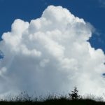
Cumulus clouds form when the air is unstable. This instability can come from an approaching weather front or when air rises and although it is cooled with altitude, it stays warmer than the surrounding air it’s penetrating. As the clouds grow vertically and expand the cumulus cloud can form into towering cumulus and as the storm matures becomes a cumulonimbus producing heavy rain, lightning, and possibly hail. |
 |
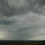
Cumulonimbus is more commonly known as thunderstorms. When high winds are at the upper reaches of the Thunderstorm the top of the cloud will form an anvil shape, pointing in the direction of the upper wind. With an approaching Cumulonimbus that produces hail, this is the most likely direction the hail will travel. The associated heavy rain, snow, hail, and lightning make these storms extremely dangerous. Cover needs to be taken until the storm passes. |
Warm Fronts
When a cold front approaches, the cold air tries to displace the warmer air from beneath. Whereas a warm front overrides the colder air announcing its arrival well in advance.
As a warm front approaches, you will notice that the basest of the clouds will lower. This is characterized by the approaching of high clouds that become lower over time. The clouds will appear in the following order:
- Cirrus
- Cirrostratus
- Altostratus
- Stratus
- Nimbostratus
As a cold front approaches and the colder air tries to push the warmer air up and cumulus clouds will form. Depending on the stability of the warm air this will determine the amount of precipitation. If the warm air that the cold air displaces is stable and moist then the precipitation that follows will be continuous. Depending on the speed of the front, the rain or snow can last for a couple of days. The clouds that form are usually stratiform
Cold Fronts
If the warm air being displaced by colder air is moist and unstable then cumuliform clouds form. Rain from Thunderstorms will be present ahead of and behind the front. Ahead of the front, there may be some convective clouds that may also produce rain. After the front passes some fair-weather cumulus clouds may develop as well. The following clouds are the signpost of a cold front.
- Cumulus
- Altocumulus
- Cumulonimbus
- Stratocumulus
Thunderstorms also form in the mountains due to heating. As the sun warms the mountain slope and in turn warms the air, the air rises. As the air rises into colder air above it expands and forms cumulus clouds. With enough expansion and lifting these cumulus clouds can rapidly turn into cumulonimbus or thunderstorms.
Things to remember while hiking and watching the weather.
Things to Remember
- Changes in weather generally come from the west
- Watch mountain peaks for cumulus clouds to form in the morning. If they do not dissipate and start to build look for afternoon thundershowers.
- If your GPS has a barometer or Altimeter, once at camp note the barometric altitude and if the altitude increases over time, pressure is decreasing. Look for a change in the weather.
If the temperature drops suddenly with an increase in wind speed, this often is an indicator of an approaching storm.