 Directions

The Shaw Lake trail is located just 3 miles beyond Big Meadow Reservoir on CO Rd 430. To get there, you can take Hwy 160 11 miles south from South Fork. Turn onto CO Rd 410 for 1.4 miles until you reach Co Rd 430.
The Trail
The Shaw Lake Trail is a 1.8-mile loop that encircles the lake. It has a total elevation gain and loss of 225 feet and should take about an hour to complete. However, you may encounter some obstacles on the east side of the lake due to fallen trees from the 2013 West Fork Fire. The trail is still passable, but it may slow you down. To estimate your trip time along the Trail, you can use the Hiking Time Calculator.
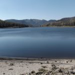
In 2020 the lake was quite low. It was mid-summer and not much rain had fallen. The Boat dock was sitting on dry land.
Options
There are a few different routes you could take if you have the time. From the northern end of the lake, there is a trail that, if followed, joins the Lake Fork trail. This trail will lead you back to Highway 160. On the southern end of the lake, you can take the Kitty Creek trail (837) to Table Mountain. After that, join trails 832 and 836, and then follow trail 800 to Hunter Lake. From there, you can continue to the Hunter Lake Trailhead. If you bypass Trail 800 and stay on Trail 836, you’ll connect with the trail from the north of Shaw Lake, which makes for a nice loop.